Drive north out of Baltimore City on York Road, take a left onto Shawan Road, pass through Hunt Valley, go under I-83, and the change is almost instant: commercial retail and industrial parks give way to horse fences and open pasture. That shift marks the Urban Rural Demarcation Line, or the URDL, Baltimore County's smart growth boundary, drawn in 1967 to separate the metropolitan area from the county's rural landscape. On a map, the line traces a shape closer to a maple leaf, or an inkblot test, wrapped around Baltimore City. Nearly sixty years later, the question worth asking is simple: has it worked?
WRT's planning team, Charles B. Neer, Nancy O’Neill, Tanushri Dalmiya, and Beth Houser, working alongside economic consultants Urban3, and Research Assistant Annie Parker from the McHarg Center at the University of Pennsylvania, set out to answer that question for the Valleys Planning Council. The study looks at the URDL through three lenses: environmental health, growth and land consumption, and rural and agricultural preservation. Presented at the Council's annual meeting this September, the findings point to the same conclusion across all three: the boundary has done what it was designed to do, and the county has a lot resting on keeping it in place.
Preserving Ecosystem Functions from Unchecked Urbanization
The area inside the URDL covers about a third of Baltimore County's land but holds 90 percent of its population. Residents inside the line rely on county water and sewer service. Outside it, homes run on private wells and septic systems, a distinction that shapes everything from development pressure to public health.
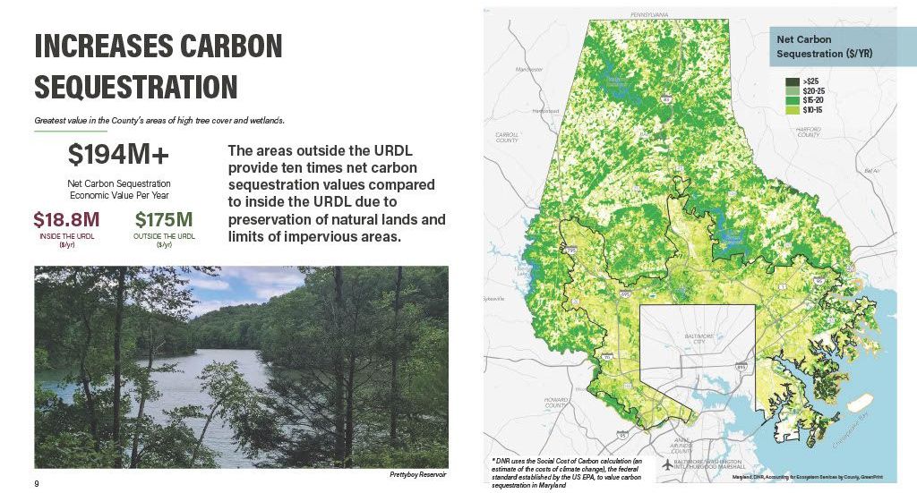
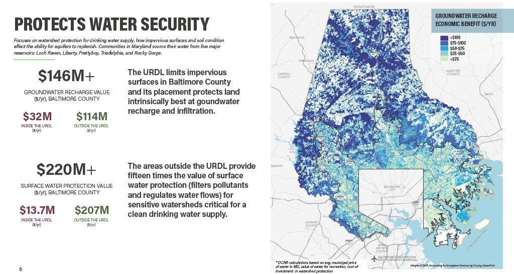
That split has a dollar value attached to it. The land the URDL keeps undeveloped, mostly forests and wetlands outside the boundary, generates over $740 million a year in ecosystem services for the county, a figure WRT calculated using data from Maryland's Greenprint program. Those same lands remove more than 17.5 million pounds of air pollutants annually and sequester ten times the carbon that developed land inside the URDL does. Nearly 70 percent of the county's most sensitive aquifers sit outside the line, which is exactly where limiting development matters most for groundwater recharge and drinking water quality. As the study puts it plainly: without that protection, the county's water supply is at risk, and there is no substitute for it.
Room to Grow Without
Moving the Line
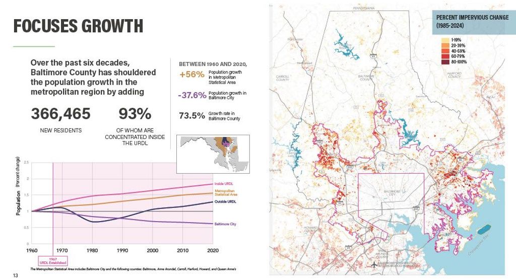
The second finding cuts against a common argument for pushing the boundary out. Since the URDL was established, Baltimore County has added more than 366,000 residents, and 93 percent of them settled inside the line. The county has absorbed most of the region's growth without expanding its footprint, largely because there is still capacity to do it again.
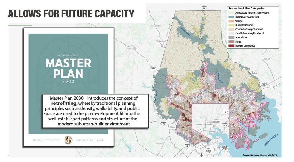
Baltimore County's Master Plan already identifies retrofit core areas built on infrastructure that already exists, along with more than 6,000 acres of vacant land and 370 acres of vacant buildings inside the URDL, zoned for medium- to high-density development. Add in the surface parking lots scattered across the county's built-up areas, enough asphalt to cover 35 football stadiums, and there is substantial room for high-quality development without a single acre added outside the line. That matters because the infrastructure math doesn't favor expansion: the county is already short millions a year on what it would take to properly maintain its existing stormwater, water, sewer, and road systems. Extending that infrastructure into rural areas only deepens the gap.
Preserving a Working Rural Landscape
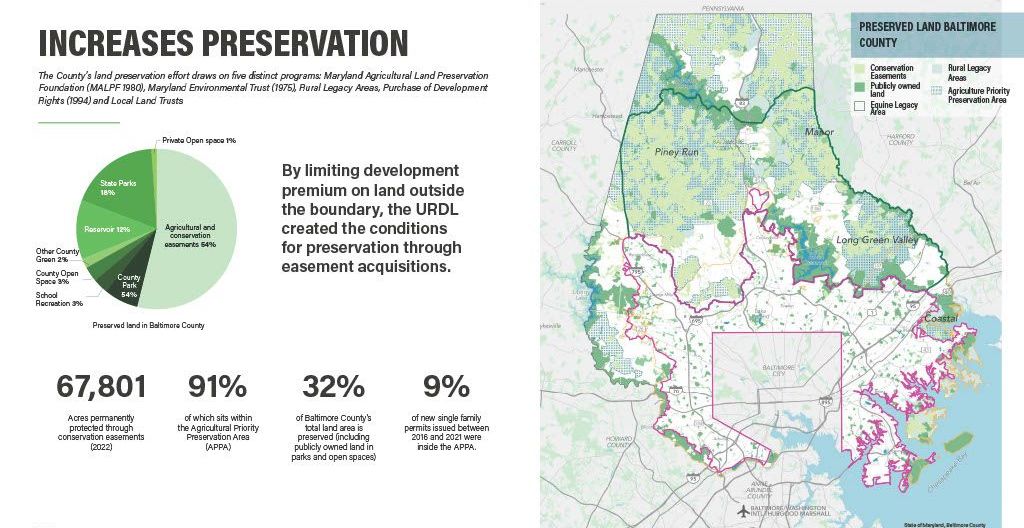
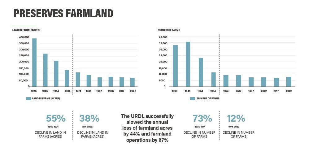
Outside the URDL, the picture is one of stability rather than decline. Resource Conservation Zoning, introduced in 1976, limits the density of new developments across the rural landscape, strengthening the effectiveness of the URDL. Dominant land cover types in that area have shifted by less than 2 percent since 1985. Nearly 68,000 acres are permanently protected through conservation easements, and the loss in acres of farmlands and numbers of farms, has been dramatically stabilized. Compared with neighboring Harford and Howard counties, which lack a similar growth boundary, Baltimore County has held onto significantly more of its farmland over the same period.